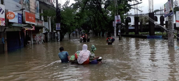
“전 세계 홍수 위험 주거지 30년간 122% 증가”
도시화 가속화로 많은 인구가 해안·저지대로 몰려…홍수 등 물재해 위험 증가
중국·베트남 등 동아시아 지역 취약…라오스·방글라데시·피지도 홍수 위험 높아
세계은행·독일 항공우주센터 공동연구팀…국제 학술지 『네이처(Nature)』에 발표
Part02. 급속한 도시화로 홍수 위험지역 급증
세계의 도시들은 사람들이 경제적인 기회를 찾아 이동함에 따라 빠르게 성장하고 있다. 도시화와 경제 발전은 전통적으로 도시가 사람, 아이디어, 자본을 유치하고 집적 경제를 육성함에 따라 함께 진행돼 왔다. 하지만, 급속한 도시화는 자연적인 위험에 대한 노출을 증가시키고 공공 서비스와 사회 기반시설에 대한 압력을 증가시킴으로써 혼잡 효과를 일으킬 수 있다.
급속한 도시화가 홍수 위험과 사람들에게 취약성을 미치는 영향은 저소득 및 중산층 국가들에게 심화되고 있는 도전이다. 이는 위험에 정통한 도시 및 기반시설 계획을 위한 역량과 보호 기반시설에 투자할 자원이 부족한 국가와 특히 관련이 있다. 또한 건설을 위한 안전한 공간이 점점 더 줄어듦에 따라 높은 인구 밀도와 토지 부족은 강바닥과 홍수 평원을 포함해 이전에 회피된 지역에 불균형적으로 새로운 개발을 유도하고 있다.
세계은행(World Bank)과 독일 항공우주센터(German Aerospace Center) 등의 연구진이 참여한 공동 연구팀이 10월 4일자 국제 학술지 『네이처(Nature)』에 발표한 ‘1985년 이래 홍수지역의 급속한 도시성장의 세계적 증거(Global Evidence of Rapid Urban Growth in Flood Zones Since 1985)’라는 연구논문에서 1985〜2015년 지구상에서 홍수에 노출된 주거지(Dwelling) 수가 122% 늘었다고 발표했다.
이 연구팀은 세계은행 산하 재해저감복구 국제본부(Global Facility for Disaster Reduction and Recovery, GFDRR)의 재정적 지원을 받은 연구에서, 시골 마을(Rural Village)에서 대도시에 이르기까지 전 세계의 지역사회가 홍수지역으로 지속적이고 빠르게 확장돼 왔다는 체계적인 증거를 밝혀냈다. 즉, 기후변화가 심한 지역에서 극심한 강수량과 홍수가 더 자주 일어날 것이라는 증거에도 불구하고, 많은 국가들은 계획되지 않은 도시 확장으로 인해 이러한 위협에 대한 노출을 계속 증가시키고 있는 것이다.
The world’s cities are growing rapidly as people move in search of economic opportunities. Urbanization and economic development have traditionally gone hand in hand as cities attract people, ideas, and capital, and foster agglomeration economies. However, rapid urbanization can also cause congestion effects; for instance, by increasing exposure to natural hazards and pressure on public services and infrastructure.
The effect of rapid urbanization on flood risks and people’s vulnerability is an intensifying challenge for low and middle-income countries. This is particularly relevant in countries that lack the capacity for risk-informed urban and infrastructure planning and the resources to invest in protection infrastructure. And as safe spaces for construction are increasingly occupied, high population density and land scarcity are driving new developments disproportionately into previously avoided areas, including riverbeds and flood plains.
A joint research team involving researchers from the World Bank and the German Aerospace Center announced in a research paper titled ‘Global Evidence of Rapid Urban Growth in Flooded Areas since 1985’ published in the international journal Nature on October 4 that the number of dwellings exposed to floods on the planet increased by 122 percent between 1985 and 2015.
The research team, with financial support from the Global Facility for Disaster Reduction and Recovery(GFDRR), provides systematic evidence that communities around the world, from rural villages to large cities, have been expanding continuously and rapidly into flood zones. Despite evidence that climate change will cause extreme precipitation and flooding more frequently in many areas, many countries continue to increase their exposure to such threats with unplanned urban expansion.
동아시아 및 중상위 소득 국가, 가장 빠른 고위험 성장
이 연구논문에 따르면, 많은 지역에서 홍수지역의 증가가 안전 지역의 성장을 훨씬 앞지르고 있다. 특히 동아시아의 경우 홍수 위험도가 높은 정착지(Settlement)가 홍수 안전 지역보다 60%나 빠르게 증가하고 있는 것으로 나타났는데, 일반적으로 지난 수십 년간 경제 및 도시가 급속하게 성장한 중간소득국가(Middle-income Countries, MIC)의 경우도 그러하다. 그 영향은 다른 어떤 그룹보다 홍수에 가장 위험한 지역에 정착하는 비율이 높은 중상위소득국가에서 1985년 이후 184% 증가했는데, 이는 홍수로부터 안전한 정착지 비율(96%)에 거의 두 배에 달했다.
이렇게 홍수 위험도가 높은 지역에 정착하는 것은 미래의 손실과 지속적으로 증가하는 홍수 보호 투자의 필요성을 줄이지 못할 뿐만 아니라 홍수에 노출시킨다. 특히 중국과 베트남은 지난 30년 동안 정착 범위가 3배 이상 증가해 육지 면적보다 훨씬 더 많이 늘어났다. 대부분의 국가, 특히 동아시아 국가에서는 건조한 지역보다 일반 홍수지역과 초고도 홍수지역에 더 많은 사람들이 주거하는 곳으로 나타났다. 지난 9월 엄청난 홍수를 겪은 리비아는 최악의 홍수지역에서 정착 범위가 83% 증가했고, 2022년과 올해 모두 엄청난 홍수피해를 입은 파키스탄의 경우 89% 증가했다.
Most rapid high-risk growth in East Asia, and upper-middle-income countries
In many regions, growth in the most hazardous flood zones has been outpacing growth in safe zones by a large margin. This is particularly true in East Asia, where high-hazard settlements have expanded 60% faster than flood-safe ones. More generally, this is true in middle-income countries(MIC), where economies and cities have grown rapidly over the past decades. The effects are most visible in upper-middle-income countries, which have a higher proportion of settlements in the highest-hazard areas than any other group. Since 1985, these have grown by 184% - nearly twice the rate of flood-safe settlements (96%).
These expanding settlements in high-hazard areas lock in flood exposure, as well as future losses and the need for ever-mounting flood protection investments. China and Vietnam both saw their settlement extent more than tripling in the past 30 years, increasing far more than their dry land areas. Most countries, especially in East Asia, saw more settlements in regular flood zones and ultra high flood zones than in dry areas. Libya, which suffered from devastating flooding last month, had an 83% increase in settlement extent in the worst flood zones. Pakistan, also the victim of catastrophic flooding both last year and this year, had an 89% increase.
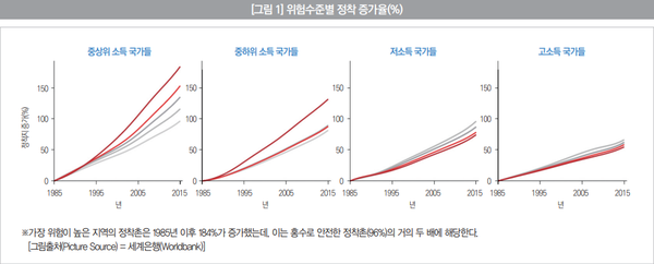
저소득국가, 느리고 안전한 도시 성장
저소득국가(Low-income Counties, LIC)는 중간소득국가(MIC)와 비교할 때 1985년 이후 정착지가 완만하게 증가했으며 이러한 증가는 대부분 안전한 토지에서 발생한다. 평균적으로 홍수 위험도가 높은 지역의 정착지는 77% 증가한 반면 안전한 지역의 정착지는 87% 증가했는데, 이들 국가의 도시화가 지체돼 홍수 위험도가 높은 토지를 포함한 모든 가용 토지를 사용해야 하는 압력이 줄어들 가능성이 있다.
이러한 추세는 바뀔 가능성이 높다. 오늘날 저소득국가(LIC)가 경제성장의 길을 따라감에 따라 도시화 속도가 빨라질 가능성이 높고, 이는 더 빠른 개발에 도움이 되지만 위험에 대한 정보가 있는 도시계획과 적절한 구역제 정책이 없다면 미래에는 저소득층 도시중심지의 기후위험 노출이 증가할 가능성이 높다.
Slow and safe urban growth in low-income countries so far
Compared with MICs, low-income countries (LIC) have seen moderate settlement growth since 1985, and this growth is mostly occurring on safe land: on average, settlements in high-hazard areas have grown 77%, compared to 87% in safe areas. The slower urbanization in these countries is likely to create less pressure to use all available land, including the riskiest one.
These trends are likely to change in the future. As today’s LICs follow on a path of economic growth, urbanization rates are likely to accelerate, which is conducive to faster development. But without risk-informed urban planning and appropriate zoning policies, climatic risk exposure in low-income urban hubs is likely to increase in the future.
도시계획과 기후 회복력에 대한 의미
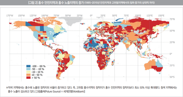
기후변화를 지역당국의 영향을 넘어 재난을 발생시키는 외력으로 보는 것은 정치적으로 편리할 수 있지만, 지역적으로 결정된 도시화 패턴과 공간 개발은 사람들의 노출과 기후 충격에 대한 취약성의 핵심 요인이 될 수 있다. 지역적으로 세분화된 결과는 홍수 위험에 대한 노출의 차이 패턴을 보여준다. 일부 지역에서는 홍수 안전 성장이 지배적인 반면, 다른 지역에서는 홍수에 대한 상대적 노출이 증가하고 있다. 이는 토지 이용 및 도시화 계획과 규제·집행을 담당하는 지방자치단체 및 지방정부의 주요 책임을 강조한다.
홍수로 인한 재해 손실이 증가하는 시대에 효과적인 홍수 위험 완화 노력은 홍수 위험의 다양한 기여 요인에 대한 철저한 이해를 기반으로 해야 한다. 여기에는 △기후변화로 인한 위험 증가 △위험에 처한 거주지 확장으로 인한 위험 노출 증가 △부적절한 건축 표준 또는 사회 보호 시스템으로 인한 충격에 대한 취약성 증가 등이 포함될 수 있다.
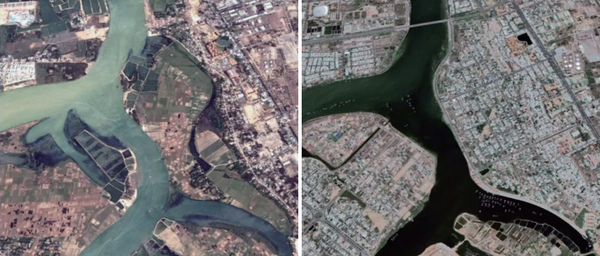
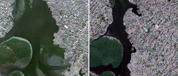
연구팀은 매년 고해상도의 위성 사진을 분석하는 방식으로 전 세계 주거지 변화를 추적했다. 홍수 위험 등급은, 홍수피해 가능성이 없는 0등급부터 100년에 한번 수심 1.5m 이상의 홍수 발생 위험이 있는 4등급까지 모두 5개 등급으로 분류했는데, 홍수 위험이 큰 지역(3등급)과 아주 큰 지역(4등급)에 건설된 주거지는 전체 주거지의 11.3%로 추정되는 것으로 나타났다.
이 논문의 공동저자이자 세계은행 선임 기후자문관이자 재해경제 전문가인 스테판 알레가트(Stephane Hallegatte)는 “우리의 연구는 시공간 해상도가 높은 데이터를 사용해 노출 증가가 홍수 재해 손실의 전 세계적 증가를 이해하는 데 핵심이라는 것을 보여주는 것으로 도시화 및 홍수 노출 패턴을 지속적으로 모니터링하면 시기 적절한 개입을 안내하는 데 도움이 될 수 있다”고 말했다. 그는 이어 “이러한 연구결과는 도시계획가와 정책 입안자들에게 구체적인 시사점을 주고 있다”면서 “이미 홍수 노출량이 많은 지역에서 손실을 완화하기 위해서는 재난대비 및 보호에 대한 투자(예 : 조기경보시스템, 사회보호 및 보호인프라)가 중요하다”고 강조했다.
홍수 노출이 여전히 낮지만 빠르게 증가하는 지역에서는 가장 위험이 높은 지역의 신규 건설을 피하기 위해 토지 이용 및 도시화 계획을 수정하는 것이 급선무다. 일단 지역이 도시화되면 되돌리는 것이 불가능할 뿐만 아니라 되돌리는 데 엄청나게 많은 비용이 들어 큰 경제적, 인간적 결과를 가져오는 고위험 패턴을 고정시키기 때문이다. 토지 부족과 지리적 제약으로 인해 홍수지역을 항상 피할 수는 없지만 보호 시스템과 재해 대비를 신중하게 계획하면 회복력 있는 개발을 지원할 수 있다.
What it means for urban planning and climate resilience
It can be politically convenient to see climate change as an exogenous force that places disasters beyond the influence of local authorities. However, locally determined patterns of urbanization and spatial development are key factors in people’s exposure and vulnerability to climatic shocks. Subnationally disaggregated results show a pattern of divergence in exposure to flood hazard, with flood-safe growth dominating in some locations, while others are increasing their relative exposure to floods. This highlights a key responsibility that falls on municipalities and subnational governments, who often are charged with land-use and urbanization plans and regulations (including their enforcement).
In an age of increasing disaster losses due to flood events, effective flood risk mitigation efforts must be based on a robust understanding of the different contributing factors to flood risk. These can include intensifying hazards(e.g., due to climate change), increasing exposure to hazards(due to expanding at-risk settlements), and rising vulnerability to shocks(e.g., due to inadequate building standards or social protection systems).
The research team tracked changes in residential areas around the world by analyzing high-resolution satellite images every year. The flood risk level is classified into five levels, from level 0, which has no possibility of flood damage, to level 4, where there is a risk of flooding with a depth of 1.5 m or more once every 100 years. Areas with a high risk of flooding (level 3) and areas with a very large area It was found that residential areas built in (Level 4) are estimated to be 11.3% of all residential areas.
“Our study uses data with high spatial and temporal resolution to show that increasing exposure is key to understanding the global increase in flood disaster losses,” said Stephane Hallegatte, co-author of the paper, World Bank senior climate advisor and disaster economics expert. “Continuous monitoring of urbanization and flood exposure patterns can help guide timely interventions,” he said. These findings have concrete implications for urban planners and policy makers. In areas where flood exposure is already high, investments in disaster preparedness and protection are crucial to mitigate losses (e.g. early warning systems, social protection, and protective infrastructure).
In areas where flood exposure is still low but rapidly increasing, revision of land use and urbanization plans are urgent priorities to avoid new construction in the highest-risk areas : once an area is urbanized, it is impossible or prohibitively expensive to reverse it, thus locking-in high-risk patterns with large economic and human consequences. While land scarcity and geographic constraints can mean that flood zones cannot always be avoided, careful planning of protection systems and disaster preparedness can support resilient development.
홍수지역 급속한 도시성장, 1985년 이래 세계적 증거
앞에서 언급했듯이 많은 국가들이 빠르게 도시화함에 따라, 정착지들은 위험한 홍수지역으로 확대되고 있다. 이 연구는 1985년에서 2015년 사이에 공간 도시화 패턴과 홍수 노출의 증가에 대한 세계적인 분석을 제공했다. 고해상도 연간 데이터를 사용함으로써 이 연구는 전 세계의 정착촌들이 85% 증가해 128만㎢을 넘어섰음을 보여준다. 같은 기간에 홍수 위험수준이 가장 높은 곳에 노출된 정착지들은 122% 증가했다.
30년 사이 홍수 위험 4등급 정착지가 많이 늘어난 나라로는 아랍에미리트(412.7%), 남수단(333.9%), 베트남(289.5%), 중국(226.2%) 등이 꼽혔다. 지난 9월 10일 대홍수가 발생해 1만여 명 이상 숨진 리비아는 홍수 위험 4등급 정착지가 82.7%인 것으로 나타났다. 특히, 전체 정착지 가운데 홍수 위험이 큰 곳의 비중이 가장 높은 나라들로는 네덜란드, 베트남, 라오스, 방글라데시, 피지가 꼽혔으며 북한은 홍수 위험 지역의 비중이 11번째로 높은 나라였고, 한국은 18번째였다.
많은 지역에서 위험한 지역의 증가가 안전한 지역의 증가를 앞지르고 있으며, 특히 동아시아의 경우 위험도가 높은 정착촌이 안전한 정착촌보다 60%나 빠르게 확장되고 있으며 개발도상국들이 최근의 홍수 노출량 증가를 주도하고 있다. 1985년 이래로 세계에서 가장 위험도가 높은 지역에 3만650㎢의 정착지가 세워졌으며, 그 중 82%가 중저소득국가에 있다. 이에 비해 최근 고소득국가들의 성장은 상대적으로 느리고 안전하다. 이러한 결과는 홍수 위험에 대한 국가들의 노출의 차이를 기록하고 있다. 많은 국가들이 기후 위험에 대한 노출을 적응시키기보다는 적극적으로 노출을 늘리고 있다.
이 논문의 공동저자이자 세계은행 선임 기후자문관이자 재해경제 전문가인 스테판 알레가트(Stephane Hallegatte)는 “많은 사람들이 더 나은 삶과 일자리를 찾는 과정에서 생활하기 좋지 못한 땅에 발목이 잡히는 형국”이라면서 “이들은 그러한 곳에 도착하면 위험하다는 것을 깨닫는다”라고 지적했다. 그는 이어 “가난한 나라는 중산층 국가가 현재 겪고 있는 함정에 빠지는 것을 막을 수 있다”면서 “도시 개발과 현명한 계획을 통해 일부 사람들이 가장 위험한 곳으로 이동하는 것을 막을 수 있다”고 덧붙였다.
또 세계은행 경제학자이자 이번 연구의 책임자인 준 렌츨러(Jun Rentschler)는 “현재 일어나고 있는 일은 국가가 조금 더 부유해짐에 따라 시골이 도시로 변화하고 많은 사람들이 도시로 가기 위해 나라를 떠난다는 것이다. 도시는 종종 범람하는 강·하천 근처에 있는 경우가 많다”면서 “우리가 연구를 통해 하려는 것은 시간이 지남에 따라 도시개발 과정을 추적하는 것”이라고 말했다.
렌츨러 연구책임자는 특히 “많은 사람들이 예상하는 것은 처음에는 안전한 공간에 정착하지만 도시가 확장됨에 따라 이전에 피했던 지역, 예를 들어 홍수지역으로 도시가 성장할 가능성이 더 높다. 그런 다음 이러한 위험한 지역을 강화하는 것이 더 저렴할 것인지, 아니면 사람들을 이동시키는 것이 더 나은 것인지에 대한 문제가 발생한다”고 강조했다.
Publication: Rapid Urban Growth in Flood Zones: Global Evidence since 1985
As countries rapidly urbanize, settlements are expanding into hazardous flood zones. This study provides a global analysis of spatial urbanization patterns and the evolution of flood exposure between 1985 and 2015. Using high-resolution annual data, it shows that settlements across the world grew by 85 percent to over 1.28 million square kilometers. In the same period, settlements exposed to the highest flood hazard level increased by 122 percent.
The United Arab Emirates(412.7 percent), South Sudan(333.9 percent), Vietnam(289.5 percent), and China(226.2 percent) were among the countries that have seen a significant increase in flood risk fourth-class settlements over the past 30 years. Libya, where more than 10,000 people died in a heavy flood on September 10, has 82.7% of flood-risk fourth-class settlements. The Netherlands, Vietnam, Laos, Bangladesh, and Fiji were ranked as the countries with the highest proportion of flood-risk areas among all residential areas, while North Korea was the 11th highest in flood-risk areas, and South Korea was the 18th.
In many regions, risky growth is outpacing safe growth, particularly in East Asia, where high-risk settlements have expanded 60 percent faster than safe ones. Developing countries are driving the recent growth of flood exposure: 36,500 square kilometers of settlements were built in the world’s highest-risk zones since 1985 - 82 percent of which are in low - and middle-income countries. In comparison, recent growth in high-income countries has been relatively slow and safe. These results document a divergence in countries’ exposure to flood hazards. Rather than adapting their exposure to climatic hazards, many countries are actively increasing their exposure.
“People are on a search for better lives and better jobs and then sort of get stuck in bad lands because that’s what they can afford,” said study co-author Stephane Hallegatte, a World Bank senior climate adviser and expert on disaster economics. He said they know it’s dangerous when they arrive. And in both cases poorer countries could keep from falling into a trap middle income countries are doing now, Hallegatte said. With urban development, smart planning can prevent some of the moving into the riskiest places, he said.
What’s happening is that as a nation grows a bit wealthier there’s a change from rural to urban and people leave the country to go to cities, which are often near waterways that flood in places, said study lead author Jun Rentschler, a World Bank economist.
“What we’re trying to do with the study is to track the process of urban development over time,” Rentschler said. “What you would expect is that initially you settle in a safe space, but as the city expands, it’s more likely to grow into areas that it previously avoided, flood zones for instance. Then comes the issue of is it cheaper to fortify these dangerous areas or better to move people out”, the study authors said.
[출처 = 세계은행(Worldbank
(https://blogs.worldbank.org/sustainablecities/tracking-urban-flood-exposure-global-trends-1985) / 2023년 10월 3일자 연구보고서]
[연구논문출처 = 국제 학술지 『네이처(Nature)』 (https://www.nature.com/articles/s41586-023-06468-9) / 2023년 10월 4일자 게재 논문]
[『워터저널』 2023년 11월호에 게재]