상류 하천 경사·삼각주 개방 각도 통해 삼각주 복원 가능성 평가
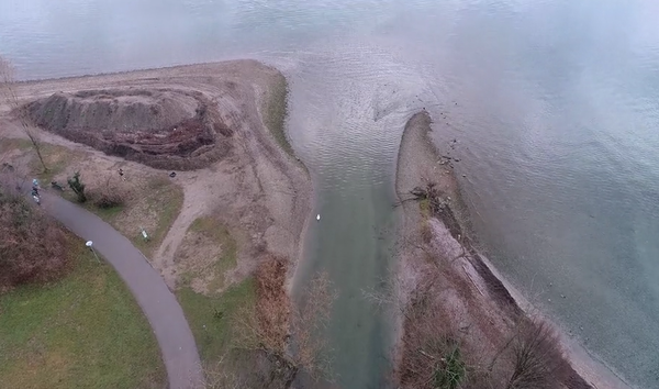
루체른(Lucerne) 호수 가장자리에 위치한 로이스 삼각주(Reuss delta)는 자갈 섬과 얕은 물줄기가 펼쳐져 식물, 동물, 이용객이 조화롭게 공존한다. 일련의 복원 프로젝트를 통해 엔지니어들은 삼각주의 자연 생태계를 재현해 생물 다양성을 증진하고 해안선을 보호하는 데 기여했다.
로이스 삼각주는 알렉산드르 포리에(Alexandre Fourrier) 로잔 연방 공과대학교(Ecole Polytechnique Federale de Lausanne, EPFL) 건축, 토목 및 환경 공학과(ENAC) 학생의 연구를 기반으로 한 호수 삼각주 복원 작업의 한 예다.
그는 석사 프로젝트를 위해 호수 삼각주의 형태학적 과정(morphological processes)을 연구했다.
그의 연구는 EPFL의 유압 건설 플랫폼의 운영 책임자인 지오반니 드 체사레(Giovanni De Cesare), 그루너 엔지니어링 회사(Gruner engineering firm)의 마리나 라나이(Marina Launay), 보 주(州)(Vaud Canton) 환경부의 스테파니 안드레(Stéphanie André)가 감독했다.
그들은 복원 작업에 앞서 엔지니어가 수행하는 예비 연구를 크게 단순화할 수 있는 새로운 방법을 개발했다. 이 연구 결과는 『생태 공학(Ecological Engineering)』 2월호에 게재됐다.
2011년 스위스는 강과 하천과 같은 수로의 복원을 의무화하는 「수자원보호법(water protection act)」 개정안을 통과시켰다. 이로 인해 론(Rhone), 로이스(Reuss) 및 아르(Aar)강과 같은 국가의 큰 강에 대한 복원 계획이 시행됐다.
보 주(Vaud Canton)에서는 2014년 이후 40km가 넘는 수로가 복원됐다. 이 법은 호숫가와 호수 삼각주에도 적용되는데, 이는 호숫가의 3%만이 자연 상태로 남아있는 제네바(Geneva) 호수에 특별한 도전을 제시했다.
강과 호수의 재연결
19세기 후반 이래로 인간 활동에 의해 자연 환경이 변화하는 인류화(Anthropization)가 점점 더 큰 규모로 진행되고 있다. 대표적으로 홍수를 막기 위한 댐 건설을 예로 들 수 있으며, 강 삼각주에 농장, 제조 공장 및 기반 시설을 건설하기도 한다.
포리에는 “오늘날 삼각주를 복원한다는 것은 제방을 개방하고 생물 다양성을 증진할 수 있는 다양한 서식지를 개발할 수 있는 공간을 만드는 것을 의미한다”며 “또한 강이 삼각주로 다시 흐르도록 하며, 이를 통해 강물에 의해 운반된 퇴적물이 강 하구에 퇴적돼 파도와 호수 흐름으로 인한 침식을 방지하는 데 도움이 된다”고 말했다.
포리에는 “로이스 삼각주의 인류화로 인해 해안선이 100미터 이상 후퇴했다”고 덧붙였다.
포리에와 그의 동료들이 개발한 방법은 단 두 개의 매개변수에만 의존하기 때문에 적용하기 쉽다는 장점이 있다.
포리에는 “엔지니어들은 상류 하천의 경사와 삼각주의 개방 각도를 통해 삼각주의 복원 가능성을 평가할 수 있다”고 말했다.
이 방법은 형태에 따라 강을 분류하는 다이어그램을 생성한다. 이를 통해 설계 엔지니어는 하천의 실제 기울기를 감안할 때 하류의 호수 형태 생성 매개변수를 고려하지 않고 삼각주가 이상적으로 채택할 수 있는 모양을 결정할 수 있다.
그루너(Gruner)의 전문가들은 보 주(Vaud Canton)와 함께 수행한 복원 프로젝트를 기반으로 이러한 접근 방식의 필요성을 확인했다.
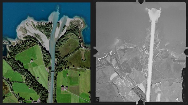
엔지니어들은 문헌 검색과 전 세계 약 200개의 호수 삼각주에 그들의 방법을 적용하여 4가지 형태 유형을 식별했다. 이를 위해 엔지니어들은 스위스 공무원이 수집한 1920년대 항공 지형 이미지와 Google 어스 이미지를 사용했다.
이 이미지를 통해 엔지니어들은 과거 연속적인 개발에 따른 강 삼각주의 변화를 확인했다. 예를 들어, 1850년에 로이스 삼각주는 85도의 개방 각도를 가졌지만, 제방이 건설되고 다른 형태의 인류화가 일어나면서 삼각주는 직선으로 변형됐다.
초기 복원 프로젝트는 1990년대에 완료돼 강에 훨씬 더 많은 공간을 제공했다. 오늘날 삼각주의 개방 각도는 60도이다.
드 체사레(De Cesare)는 “이 사례 연구는 인구 증가, 도시 개발 및 강 하구 근처의 농업과 관련된 현대의 제약을 고려하면서 삼각주를 가능한 한 원래 상태에 가깝게 복원할 수 있는 방법을 전문가들에게 보여준다”고 말했다.
[원문보기]
Engineers facilitate the restoration of lake deltas
The Reuss delta on the edge of Lake Lucerne is once again a nature-lover’s paradise, complete with gravel islands and stretches of shallow water where plants, animals and bathers coexist in harmony. Thanks to a series of restoration projects, engineers have been able to recreate the delta’s natural ecosystem, fostering biodiversity and helping to protect the shoreline. It’s a far cry from the riprap that had previously dominated the landscape. The Reuss delta is one example of the lacustrine delta restauration work that Alexandre Fourrier studied as an environmental engineering student at EPFL’s School of Architecture, Civil and Environmental Engineering (ENAC). For his in-company Master’s project, he investigated morphological processes in lacustrine deltas. His research was supervised by Giovanni De Cesare, the operational director of EPFL’s Hydraulic Constructions Platform, Marina Launay from the Gruner engineering firm, and Stéphanie André from Vaud Canton’s department of the environment. They developed a new method that can drastically simplify the preliminary studies performed by engineers ahead of restoration work. The study findings were published recently in Ecological Engineering.
In 2011, Switzerland passed an amendment to its water protection act making it mandatory to restore watercourses such as rivers and streams. This led to the implementation of restoration plans for the country’s large rivers such as the Rhone, Reuss and Aar. In Vaud Canton, over 40 kilometers of watercourses have been restored since 2014. The law also applies to lakeshores and lacustrine deltas – and this poses particular challenges for Lake Geneva, where only 3% of the shore is still in its natural state.
Reconnecting rivers and lakes
Since the late 19th century, anthropization – the alteration of natural environments by human activity – has been taking place on a growing scale. One example is the construction of dams to prevent flooding. Often, anthropization involves building farms, manufacturing plants and infrastructure on river deltas. “Today, restoring these deltas means opening up dikes and creating space for a range of habitats to develop that can support biodiversity,” says Fourrier. “It also means allowing rivers to flow back into lacustrine deltas, which all have their own dynamics. This would allow the sediment carried in river water to be deposited at the river mouth, thus helping to prevent the erosion caused by waves and lacustrine currents.” He offers a telling example: “Anthropization in the Reuss delta has caused the shoreline to recede by over 100 meters.”
The method that Fourrier and his colleagues developed has the advantage of being particularly easy to use, since it relies on just two parameters. “Engineers can use it to evaluate a delta’s restoration potential by entering the slope of the upstream watercourse and the opening angle of the delta,” he says. The method can also help determine the space required for the water course to fulfill its natural functions. The method results in a diagram like the ones used to classify rivers according to their morphology. “Alexandre’s approach is a genuine breakthrough because this type of classification had never been done before for river deltas,” says De Cesare. Experts at Gruner had identified the need for such an approach based on restoration projects they had carried out in conjunction with Vaud Canton.
Traveling through time
The engineers identified four different morphology types, partly through a search of the literature, and partly by applying their method to some 200 lacustrine deltas around the world. For that, they used images available on Google Earth along with aerial topographical images dating back to the 1920s assembled by Swiss public officials.
These images enabled the engineers to travel back in time and see the changes in river deltas following successive development projects. For instance, in 1850 the Reuss delta had an 85-degree opening angle, but as levees were built and other forms of anthropization occurred, the delta morphed into a straight line. An initial restoration project was completed in the 1990s, giving the river much more space. Today, the delta has an opening angle of 60 degrees. “This case study shows experts how they can restore deltas to as close as possible to their original state while taking into account modern-day constraints associated with population growth, urban development and farming near the river mouth,” says De Cesare.
[출처 = EPFL(https://actu.epfl.ch/news/engineers-facilitate-the-restoration-of-lake-delta/) / 2024년 3월 6일]
[번역 = 박원희 기자]