기록적인 폭염, 잦은 홍수와 산불에 이르기까지, 기후 변화의 영향은 이미 존재하며, 우리 모두에게 영향을 미치고 있다.
구글는 AI 기반 예측 및 솔루션을 구축해 지역 사회가 사전에 대비·계획할 수 있도록 정보를 제공한다.
더 많은 장소에서 홍수 예측
구글 리서치(google Research)는 2018년부터 홍수 예측 이니셔티브를 추진하고 있다. 이는 고도화된 AI 및 지리 공간 분석을 활용해 실시간 홍수 정보를 제공하며, 지역사회와 개인이 하천 홍수에 대비하고 대응할 수 있도록 알린다.
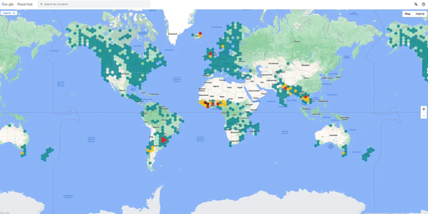
실시간 홍수 예측과 시각화는 홍수 허브(Flood Hub) 플랫폼 및 검색, 지도를 통해 제공받을 수 있다.
올해 초, 구글은 홍수 허브의 적용 범위를 80개국으로 확대해 아프리카, 아시아 태평양 지역, 유럽, 남미 및 중남미 전역의 4억 6천만 명에게 최대 7일 전에 예측을 제공했다.
지난 8월, 홍수 허브는 칠레의 지역 비상 대응 기관에 정보를 제공해, 대피 경보를 발령하고, 지역 사회가 사전 조치를 취할 수 있도록 하며, 홍수의 영향을 최소화하는 데 중요한 역할을 했다.
지난 10월, 구글은 홍수 허브의 하천 범람 예보를 미국과 캐나다로 확장해, 1천 2백만 명 이상이 살고 있는 강가 800여 곳을 포괄할 것이라고 발표했다.
구글은 AI를 통해 전 세계에 홍수 예측을 제공하고 더 많은 종류의 홍수를 다루기를 기대하며, 이를 위해 지역사회, 정부, 학계, 세계기상기구 등의 파트너들과 지속적으로 협력할 예정이다.
![미국 산림청 소방과학연구소에 방문한 구글 연구팀 [사진출처(Photo source) = Google]](https://cdn.waterjournal.co.kr/news/photo/202310/71377_43059_5940.png)
산불 경계 추적 및 화재 확산 예측
산불이 빈번해짐에 따라 구글은 화재 발생 장소에 대한 정보를 제공하기 위해 노력하고 있으며, AI가 화재가 퍼지는 장소를 예측하는 방법도 모색하고 있다.
올해 구글의 ‘SOS 경보’는 전 세계 120개 산불 사건에서 3천만 명 이상의 사람들에게 시기적절한 안전 정보를 제공했다.
산불 경계 지도를 지원하기 위해 구글의 산불 경계 추적기는 AI와 위성 이미지를 사용해 대형 화재를 실시간에 가깝게 매핑하고 15분마다 업데이트한다. 이 기능은 미국, 캐나다, 멕시코, 호주 등 화재에 취약한 지역의 구글 검색 및 지도에서 확인할 수 있으며, 적용 범위를 확대하기 위해 노력하고 있다.
또한 구글은 미국 산림청과 협력해 현재 화재 확산 모델을 50년 만에 최대 규모로 업데이트했다. 이 모델은 기계 학습(ML)을 활용해 소방 당국이 소방관을 훈련시키고, 효과적인 연료 처리를 계획하며, 현장에 있는 동안 대형 화재를 보다 안전하고 효과적으로 진압할 수 있도록 더 많은 소방 역학을 모델링한다.
![쿨 루프는 AI 및 항공 이미지를 사용해 도시 태양 반사율 측정한다 [사진출처(Photo source) = Google]](https://cdn.waterjournal.co.kr/news/photo/202310/71377_43061_037.png)
극심한 폭염에 대응할 수 있도록 지원
구글이 올해 출시한 폭염 경보를 통해 폭염에 대한 정보를 검색하면, 폭염이 시작되고 끝날 것으로 예측되는 시기, 체온 유지 방법, 글로벌 열 건강 정보 네트워크(GHHIN)에서 알아야 하는 관련 건강 문제를 볼 수 있다.
구글은 폭염 경보 출시 이후 80개국 이상 국가에 폭염 정보를 제공했다.
한편, 도시는 열을 흡수하고 재방출하는 도로나 건물 등의 구조물로 인해 기온이 높아지는 '열섬'을 예방하기 위한 방안을 모색하고 있다.
구글의 환경 인사이트 탐색기(Environmental Insights Explorer)의 일부인 나무 캐노피(Tree Canopy)는 AI와 항공 이미지를 결합해 도시의 그늘진 지역을 보여줌으로써 도시가 열을 줄이기 위해 더 많은 나무를 심어야 할 곳을 파악할 수 있도록 돕는다.
구글은 전 세계 2천 개 이상의 도시로 나무 캐노피 데이터를 확장하고 있으며, 더 많은 파트너와 도시들이 이러한 정보에 접근하고 통찰력을 활용할 수 있도록 지원하는 것을 목표로 한다.
최근 미국의 아메리칸 포레스트(American Forests)와 제휴해 수목 형평성 스코어(Tree Equity Score)에서 나무 캐노피 데이터를 사용할 수 있도록 함으로써 도시 그늘이 공평하게 분포되도록 지원했다.
이 정보를 통해 아메리칸 포레스트는 미국 인구의 약 80%에 해당하는 2억 6천만 명의 사람들에게 나무 숲 데이터를 제공했다.
또한 구글은 열섬을 줄이는 또 다른 방법으로 ‘쿨 루프(cool roofs)’라고 불리는 반사형 지붕(reflective roofs)에 대한 통찰력을 제공했다. ‘쿨 루프’는 AI와 항공 이미지를 사용해 도시의 태양 반사율을 계산하여 도시 계획자와 정부가 어느 지역에 화이트 루프와 같은 쿨 루프 솔루션을 배포할 경우 가장 효과적일 지 식별할 수 있도록 지원한다.
파일럿은 4개 도시에서 진행 중이며, 앞으로 몇 주 내에 뉴욕, 내슈빌, 멜버른 등 11개 도시로 확대될 예정이다.
구글 관계자는 “AI는 기후 위기를 해결하는 데 중요한 역할을 하고 있다. 당사가 AI 연구를 발전시킴에 따라, 기후 변화의 영향을 더욱 효과적으로 해결할 수 있으며, 전 세계의 더 많은 사람들을 도울 수 있도록 대담하고 책임감 있게 노력할 것이다”라고 말했다.
[원문보기]
How we’re using AI to combat floods, wildfires and extreme heat
From experiencing the hottest summer on record to dealing with frequent and devastating floods and wildfires, the effects of climate change are already here and impacting all of us — particularly the most vulnerable communities. As cities and individuals work to address the effects of climate change, we believe AI can play a transformative role.
We’re working to build more solutions — like our AI-based predictions and forecasting — that provide actionable information to help individuals stay safe and communities plan ahead. Here’s some of the progress we shared today at Sustainable with Google.
Forecasting floods in more places
Floods are the most common natural disaster, causing thousands of fatalities and disrupting the lives of millions every year. Since 2018, Google Research has been working on our flood forecasting initiative, which uses advanced AI and geospatial analysis to provide real-time flooding information, to help inform communities and individuals to prepare for and respond to riverine floods. Our real-time flood forecasts and visualizations are available on the Flood Hub platform and, in many cases, also on Search and Maps.
Earlier this year, we expanded Flood Hub coverage to 80 countries, providing forecasts up to seven days in advance for 460 million people across Africa, the Asia-Pacific region, Europe and South and Central America. In August for example, Flood Hub was instrumental in providing information to Chile’s local emergency response agency so they could issue evacuation alerts, enable communities to take proactive measures, and minimize the impact of floods.
Today, we're announcing the expansion of riverine flood forecasts on Flood Hub to the U.S. and Canada, covering more than 800 locations by rivers where more than 12 million people live. With the help of AI, we hope to bring flood forecasting to every country and cover more types of floods, and we’ll continue to collaborate on this with our partners in the community, governments, academia, and organizations like the World Meteorological Organization.
Tracking wildfire boundaries and predicting fire spread
As wildfires become more frequent, we’re working to provide information about where fires are — and we’re also exploring how AI can predict where a fire will spread. In 2023, our SOS alerts have provided timely safety information to over 30 million people across 120 wildfire events around the world. To help map fire boundaries, our wildfire boundary tracker uses AI and satellite imagery to map large fires in close to real-time and updates every 15 minutes. This is available on Google Search and Maps in fire-prone parts of the U.S., Canada, Mexico and Australia, and we are working to expand coverage.
In addition to knowing where wildfires currently exist, firefighters need to anticipate where they will go and how to mitigate them well before they start. I’m excited to share that we are collaborating with the U.S. Forest Service to make the biggest updates to their current fire spread model in 50 years. This model leverages machine learning (ML) to model more fire dynamics to help fire authorities train firefighters, plan effective fuel treatments, and battle large-scale fires more safely and effectively while in the field.
Helping people and cities respond to extreme heat
Extreme heat also impacts public health, and heat-related deaths are on the rise. We launched extreme heat alerts this year so when people search for information on extreme heat, they see details about when a heat wave is predicted to start and end, tips on staying cool and related health concerns to be aware of from the Global Heat Health Information Network (GHHIN). Since launching, we’ve provided information about extreme heat on Search in more than 80 countries.
Cities are also looking for ways to prevent “heat islands,” which are urban areas that experience higher temperatures due to structures like roads and buildings that absorb heat and re-emit it. Our Tree Canopy tool, part of our Environmental Insights Explorer platform, combines AI and aerial imagery to show where shaded areas are in the city, helping cities better understand where to plant more trees to reduce heat. Today, we’re expanding Tree Canopy data to more than 2,000 cities globally. Our goal is to help even more partners and cities access this information and make use of these insights. For example, we recently partnered with American Forests in the U.S. to make our tree canopy data available on their Tree Equity Score tool, ensuring shade in cities is equitably distributed. With this information, American Forests now provides tree canopy data for 260 million people – that’s nearly 80% of the U.S. population.
Another way we’re helping to reduce heat islands is by providing insights about reflective roofs — called "cool roofs". Our Cool Roofs tool uses AI and aerial imagery to map out the solar reflectivity of cities so urban planners and governments can identify which areas would benefit most from deploying a cool roof solution, such as a white roof. The pilot is live in four cities and will expand to 11 more cities in the coming weeks, including New York, Nashville and Melbourne.
AI is already playing an important role in addressing the climate crisis. As we advance our AI research, we’ll do so boldly and responsibly to help further address the effects of climate change and help more people around the world.
[출처 = 구글(https://blog.google/outreach-initiatives/sustainability/google-ai-climate-change-solutions/amp/) / 2023년 10월 10일]
[번역 = 박원희 기자]