미국수도협회(AWWA)는 9월 30일까지 진행되는 '수원 보호 주간' 캠페인에서 새로운 'AWWA 물지도' 시제품을 공개했다.
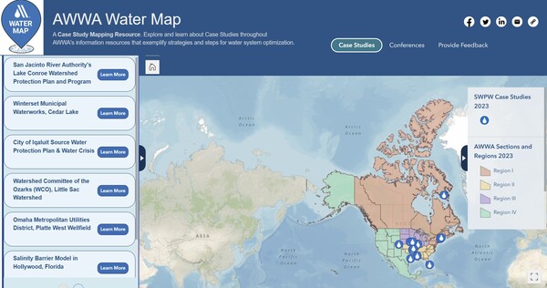
이 플랫폼은 물 분야 전문가들에게 성공적인 유틸리티 사례 연구를 탐색하고 인근 AWWA 컨퍼런스를 찾고 AWWA 섹션 및 지역에 대한 정보를 얻을 수 있는 여러 가지 상호 작용 요소를 제공한다.
매년 열리는 수원 보호 주간은 식수원 보호의 중요성을 강조하고 지역 사회, 공공 사업체 및 의사 결정자들이 그들의 지역 수원을 보호하기 위해 시행할 수 있는 전략을 공유한다. 또한 물지도 시제품을 통해 사용자들은 그들 근처의 성공적인 수원 물 보호 프로그램을 보여주는 사례 연구에 접근할 수 있다.
AWWA 물지도 시제품의 주목할 만한 기능은 다음과 같다.
- 대화형 요소: 사용자는 필터링 도구, 검색 기능, 지도 설계 요소 및 테이블 기능을 사용하여 AWWA 물지도의 경험을 사용자 정의해 자신의 관심사에 맞는 사례 연구 자료를 선별할 수 있다.
- AWWA 컨퍼런스: 시제품에는 다가오는 컨퍼런스 페이지가 포함되어 있어 사용자는 북미 전역에서 AWWA의 컨퍼런스를 확인하고 탐색할 수 있으며, 가장 가까운 이벤트에 대한 가치 있는 통찰력을 제공한다.
- 섹션 및 지역: AWWA 섹션의 업데이트된 매핑 리소스를 통해 사용자는 AWWA 섹션 및 지역에 특화된 AWWA 워터 맵 컨텐츠에 액세스할 수 있다.
AWWA 물지도 물 분야 내에서 지식을 공유하고 교류하는 것을 목표로 한다. 사용자는 자신의 위치나 조직에 가까운 곳에서 사례 연구를 탐색하고 다양한 물 프로젝트에 대한 통찰력을 얻을 수 있다.
케이시 로드리게즈(Casey Rodriguez) AWWA 수자원 지도 전문가는 "AWWA 물지도는 AWWA가 제공하는 풍부한 수계 정보를 시각적으로 정보를 제공하기 위한 역동적이고 협력적인 노력이다"라면서 "AWWA는 그들의 조직과 함께 이러한 놀라운 원천 수자원 보호 프로젝트를 이 원형 버전에서 보여주고, 그들의 독창성과 적응력에 대한 인정을 제공하게 되어 기쁘다"고 말했다.
[원문보기]
AWWA unveils AWWA Water Map prototype during Source Water Protection Week
The American Water Works Association (AWWA) is introducing a prototype of its new AWWA Water Map during this week’s Source Water Protection Week campaign that runs through Sept. 30.
The platform features several interactive elements that provide water sector professionals with the ability to explore successful utility case studies, locate nearby AWWA conferences, and obtain information about AWWA Sections and regions.
The annual Source Water Protection Week highlights the critical importance of safeguarding drinking water sources and shares strategies that communities, utilities and decision-makers can implement to protect their local water sources. Using this prototype Water Map, users can access case studies that demonstrate successful source water protection programs near them.
Some notable features of the AWWA Water Map prototype include:
Interactive elements: Users can customize their AWWA Water Map experience using filtering tools, search functions, map design elements, and table features to curate a selection of case study materials tailored to their interests.
AWWA conferences: The prototype includes an Upcoming Conferences page, enabling users to identify and explore AWWA's conferences across North America, providing valuable insights into events closest to them.
Sections and regions: With an updated mapping resource of AWWA Sections, users can access AWWA Water Map content specific to their AWWA Section and Region.
The AWWA Water Map aims to share and exchange knowledge within the water sector. Users can explore case studies in proximity to their location or organization and gain insights into various water projects. Several of the case studies feature source water protection solutions, with success stories from:
San Jacinto River Authority's Lake Conroe Watershed Protection Plan and Program
Winterset Municipal Waterworks, Cedar Lake
City of Iqaluit Source Water Protection Plan & Water Crisis
Watershed Committee of the Ozarks (WCO), Little Sac Watershed
"The AWWA Water Map is a dynamic and collaborative effort to bring forward the wealth of water system information that AWWA has to offer, but in a visually informative setting," said Casey Rodriguez, AWWA water resources mapping specialist. "We’re excited to showcase such amazing source water protection projects in this protype version, along with their organizations, and provide recognition for their ingenuity and adaptability to current water issues across the continent."
The AWWA Water Map prototype will be freely accessible to the public. However, as part of AWWA's commitment to its members, the final version of the AWWA Water Map (available in 2024) will be an exclusive benefit for AWWA members.
[출처 = AWWA(|AWWA unveils AWWA Water Map prototype during Source Water Protection Week) / 9월 26일]
[번역 = 배민수 부장]